
FOR BROKERS · BUILDERS · DEVELOPERS · INVESTORS · FRANCHISE OWNERS
What to build. What to call out. What to walk away from. Luminsite turns any commercial address into one decision-ready, branded report — designed to win the meeting, not bury it in data.
First report free · No credit card · Plans from $49.99/mo
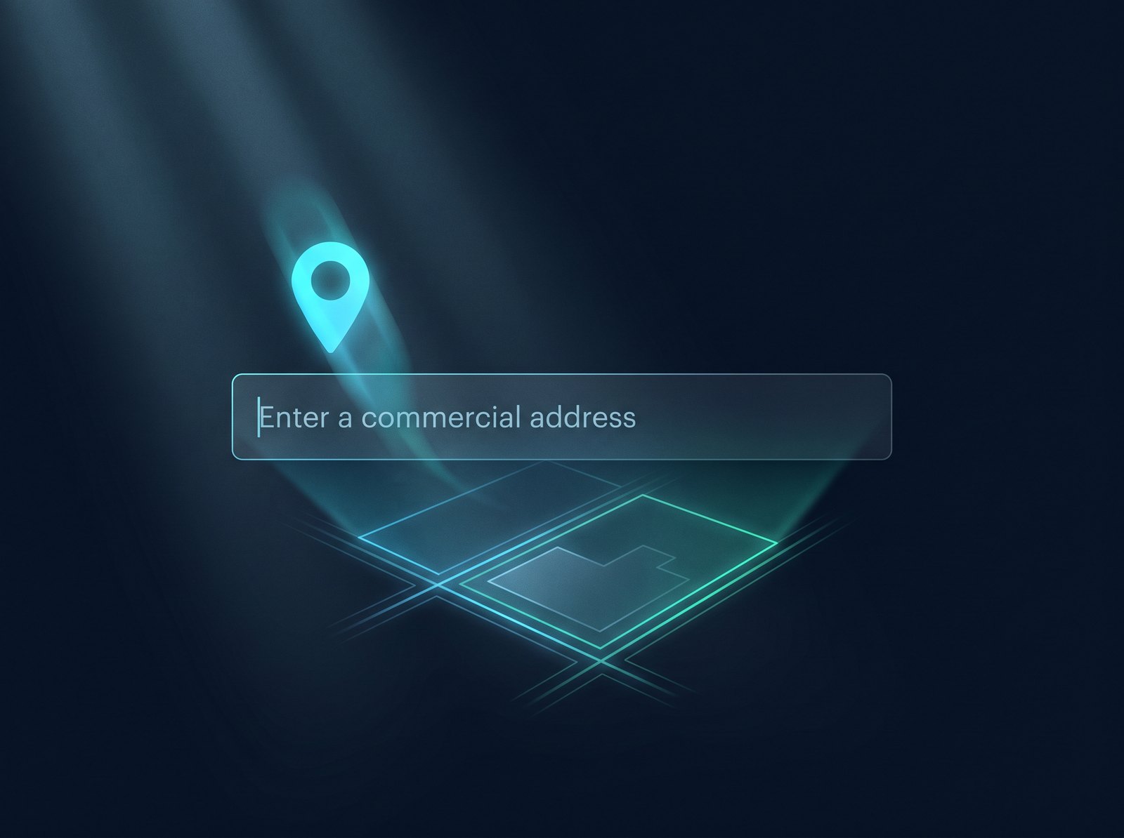
Due diligence just got easier.
60-second
Due diligence, done
Traffic counts, competitors, flood zones, zoning, utilities — pulled, cross-checked, and scored before your coffee cools.
18-point
Due diligence checklist
Same checklist the pros use — with local zoning, planning, and utility contacts already filled in.
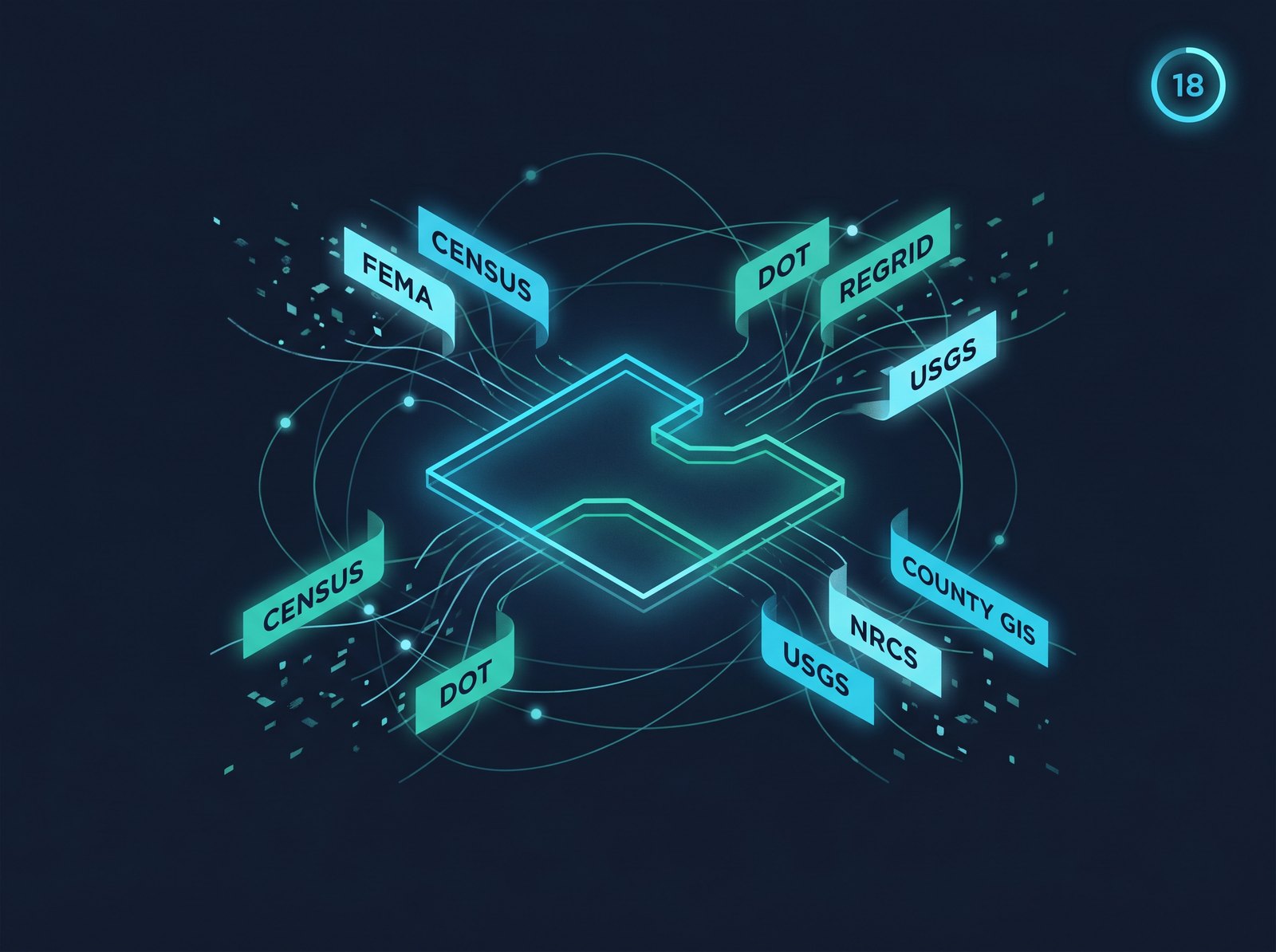
20+
Sources, one verdict
Regrid, Census, FEMA, DOT, FCC, state GIS, county records. Cross-referenced and source-attributed line by line.
5x
Faster than the alternative
What used to take a week of phone calls now lives in one branded PDF.
WHY LUMINSITE
Everyone else stops at "here's the zoning code." Luminsite tells you what it means for this deal.
DIY — free, but expensive
A consultant
Luminsite
We aggregate 20+ authoritative sources — county GIS, US Census, FEMA, USGS, NRCS, state DOT, HUD, EPA & more — into one clean read. Every line is source-attributed.
HOW IT WORKS
Outparcel, raw land, shopping center, anywhere in the US. Tell us what you're considering — retail, multifamily, industrial, mixed-use.
20+ sources pulled and reconciled in seconds. Parcel, demographics, traffic, flood, terrain, soils, zoning, utilities, competitors, comps — reconciled and scored against an 18-point due-diligence checklist.
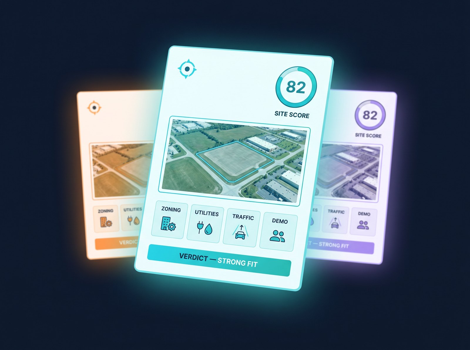
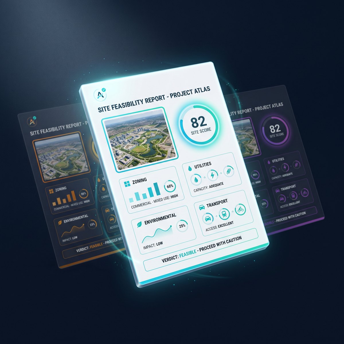
Buildable envelope, risk flags, demographics, traffic, comps — plus a plain-English read on what works and what doesn't. Client-ready PDF in your branding, shareable link, or CSV.
WHAT'S IN THE REPORT
We pull everything we can in seconds. For the rest, we tell you exactly who to call.


USGS elevation, grade analysis, cuts & fills hint.
NRCS soil class, drainage, bearing-capacity hint.
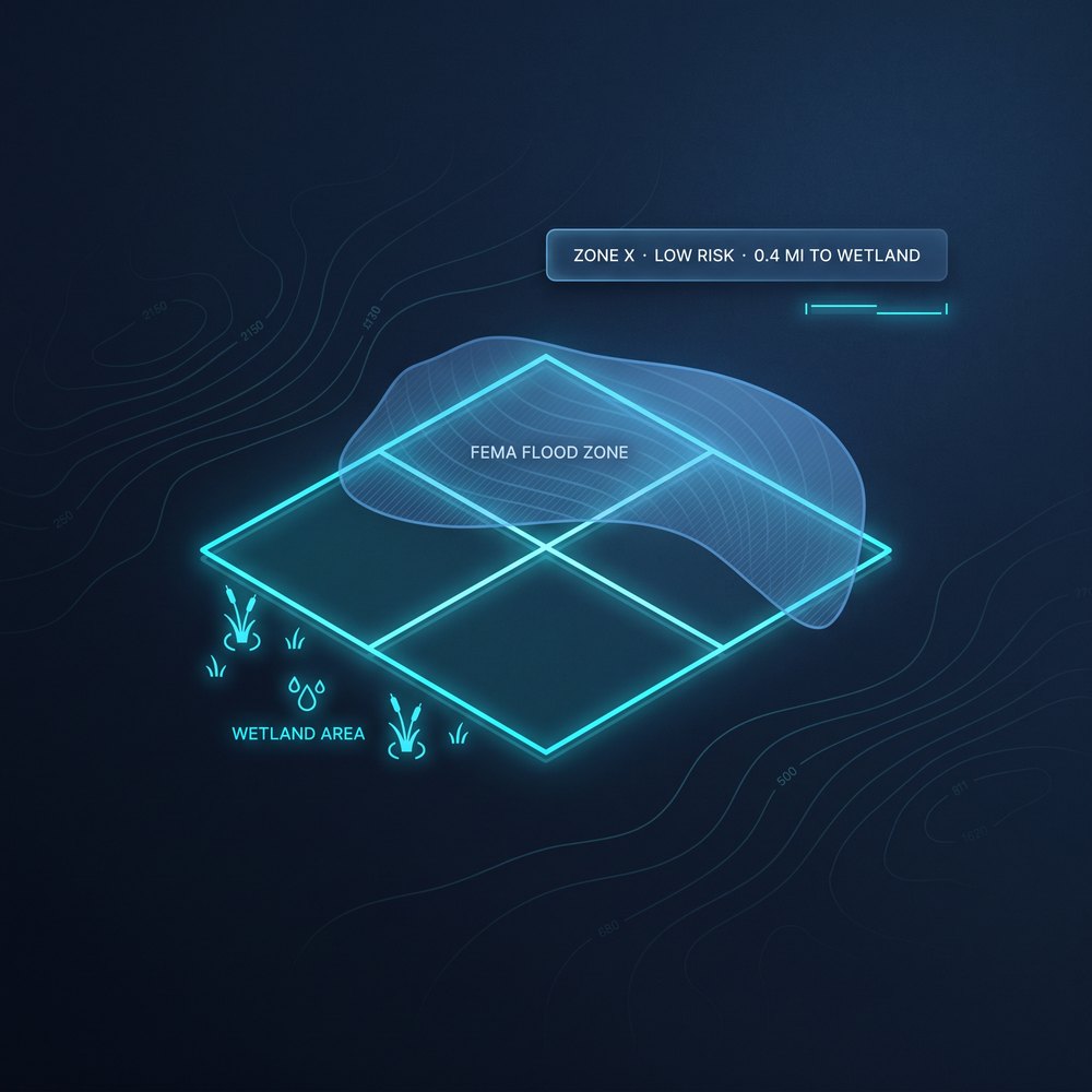
OZ flag, qualified tract, HUD overlays.
Per-acre benchmarks, comparable sales, assessor values.
THE DIFFERENCE-MAKER
Drop in your logo, photos, and colors. Professional templates designed to win the meeting, not just inform it. Same data — your brand on every page.
Pulled live from county GIS where a connector exists — 3,100+ counties and expanding. Coverage shown on entry.
Front, side, rear, height, FAR — read from local code where standardized. Otherwise flagged “verify with zoning board” with the office number.
Water, sewer, power, gas providers and lines where municipal data is published.
Our promise: we never fake a number. Where data isn't live, we give you the zoning office contact and the buildable envelope is flagged “verify.” That's the difference between a tool you can act on and one you can't.
WHO IT'S FOR
Same report, same 60 seconds — built to answer the question each of you actually asks first.

BROKERS
Hand the seller a one-page "why this site" memo on day one. Send qualified buyers a white-labeled deal book before your competitor finishes their site visit.

BUILDERS
Slope, soils, flood, setbacks, and utility access — the things that blow up a budget — surfaced before you price the job. Walk into the GC meeting already knowing the cuts & fills story.

DEVELOPERS
Screen 100 candidates a week. Walk into LOI knowing buildable envelope, slope, flood, demographics, and comps. Stop burning earnest money on sites that can't pencil.

REAL ESTATE INVESTORS
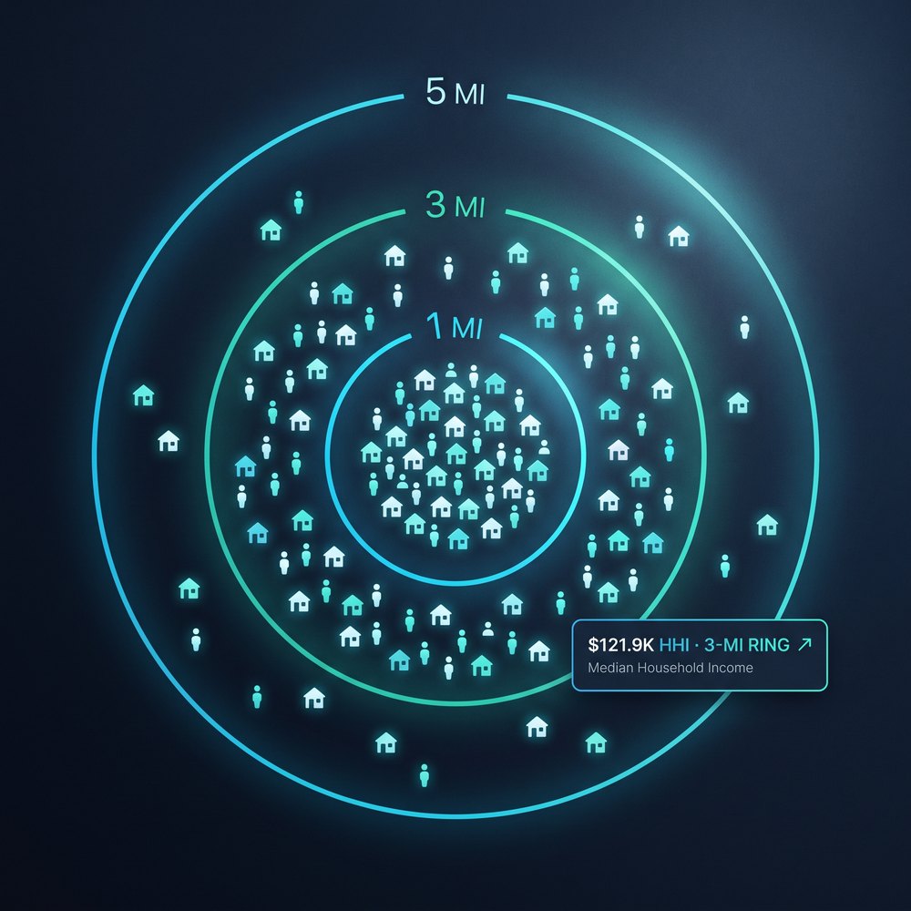
Real demographics, real traffic, real comps, your assumptions. Run sensitivity in seconds, share the deal with LPs in minutes — with a defensible source trail.

FRANCHISE OWNERS
Demographics, traffic counts, competitor mapping, and trade-area math against your brand's site criteria. Bring your franchisor a site packet that gets a green light, not a redline.
PRICING
First report free, no credit card. Cancel anytime.
Lite
$49.99/mo
Try it on real deals.
10 reports / month
Most popular
Pro
$79.99/mo
Run the deal flow.
30 reports / month
Unlimited
$129/mo
Screen at scale.
Unlimited reports
First report free — no credit card. All plans monthly, cancel anytime. Need more seats, SSO, or API access? Talk to us about Enterprise.
FOUNDING MEMBER — LIMITED COHORT
Every feature of Unlimited — for less than the Pro price — reserved for the operators helping us build it. 14-day free trial. Founding Member badge on every report. When the cohort closes, the door closes.
HOW WE DO IT
Authoritative national sources, reconciled and stitched into one source-attributed report. If a number is wrong, we tell you exactly which feed to argue with.
Zoning, setbacks, parcels
Demographics, income, ACS
Flood zones & floodways
Elevation, slope, terrain
Soils & suitability
Traffic counts & AADT
Opportunity Zones & QCT
Environmental risk & flags
National parcel boundaries
Utility providers & lines
Address standardization
We add sources monthly
Every data point carries its source attribution — verify the math, audit the call, defend the underwriting.
Try it free on a live deal. No credit card. PDF in your hands before your coffee gets cold.
QUESTIONS, ANSWERED
You can. It takes 2–4 hours per address, across 10 different tabs, and you still have to package it into something a client will read. Luminsite reconciles 20+ sources, scores them against an 18-point checklist, and hands you a client-ready, branded PDF — in 60 seconds. The math is in the time you stop spending on dead deals.
Consultants give you a static 40-page PDF in 2–6 weeks. By then your deal moved. Luminsite gives you the same data — packaged in a client-ready, branded report — in seconds, for less than a tank of gas per site. Use us to screen, use a consultant only on the one site you actually close.
In counties with a standardized zoning feed (3,100+ and expanding), yes — front, side, rear, height, and FAR come back in the same report. In counties without a published feed, we surface the zoning code if we can read it from county GIS, flag the buildable envelope as “verify with zoning board,” and give you the office number. We never fake a setback.
Every US address still returns flood, wetlands, slope, demographics, parcel, traffic, OZ, and the full due-diligence checklist. Zoning and setbacks need a county GIS connector — when missing, the report calls it out and hands you the zoning office contact.
That's coming in the Offering Memorandum Builder — a separate Luminsite product launching later this year. The Site Report you get today is laser-focused on due diligence and client presentation. When OM Builder ships, every Luminsite report will roll straight into a fully underwritten OM with one click.
Luminsite identifies and reports on individual outparcels within shopping centers and mixed-use developments — even when the official parcel record points to the parent center. Critical for retail, QSR, and pad-site deals.
You'll get a one-click upgrade prompt to the next tier — no overage charges, no surprise bills. Lite → Pro is $30, Pro → Unlimited is $49. Upgrade mid-month and we prorate it.
If you're prepping one or two deals a month, Lite. If you're an active broker, builder, or franchise hunter running 10–30 sites a month, Pro. If you're screening pipelines or running a development shop, Unlimited. Start on Lite — you can upgrade in one click any time.
Yes. Plans are month-to-month, no contract. Founding Member pricing keeps your locked rate as long as your subscription stays active — even if our retail prices go up.
GET IN TOUCH
Questions about coverage, enterprise pricing, or a partnership? Send a note and we will reply within one business day.